BC Public Lands Subscription
The BC Public Lands subscription includes 8 different map layers: General Use Crown Land, Private Land, Conservation Lands, No Hunting Zones, Crown Lease Land, Municipalities, Parks and Protected areas, and Recreation Sites and Trails.
To use these layers on your map, first make sure you have iHunter BC:


Then either try it free for 3 days or subscribe for only $9.99 per year to benefit from the layers being updated annually.
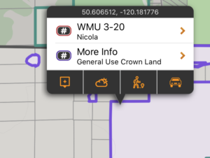
General Use Crown Land
94% of British Columbia is made up of public land, and the vast majority of this land is publicly accessible. By taking the land boundaries of BC and subtracting out the boundaries of all private land, conservation land, parks, protected areas, reserves, leases, and other federal land, we derived the ‘General Use Crown Land’ Layer.
There may be additional access restrictions on this land that are not documented in openly available GIS layers, and it is the users responsibility to obey all posted restrictions in the field. Although we have done our best to ensure this is accurate, discrepancies may exist. This layer should be used as a guideline only.
These areas are shown in a purple color, and are built into the app as part of the subscription. They can be used even without cell coverage.
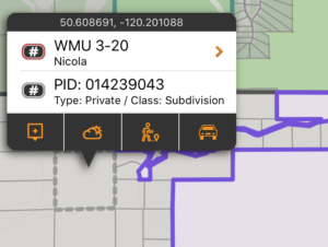
Private Land
Although making up only 6% of land in BC, private land is important because permission is required to access it. Knowing the size and shape of a piece of land makes it easier to discuss with a landowner, and being more informed could help with obtaining permission.
These areas are shown in a grey with a semi-transparent white filling the areas on the map. Each time a new area of the map is viewed, or a new zoom level is looked at, that portion of thelayer needs to be downloaded (requiring cell or Wifi service). Once downloaded, those tiles are cached on device for future offline use.
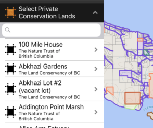
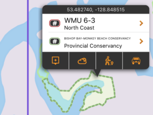
Conservation Land
Many parcels of private land are owned by Conservation organizations such as Ducks Unlimited, Nature Conservancy of Canada, The Nature Trust of British Columbia, Central Okanogan Land Trust, and the Denman Conservancy Association. This layer maps and lists these private conservation lands in a searchable manner, and provides links to access conditions for those lands. Public access varies from organization to organization, and the user is responsible for determining access using the links provided.
These boundaries are shown in pale orange on the map, and are built into the app as part of the subscription. They can be used even without cell coverage. Tapping on the area will give additional information about the selected conservation land.
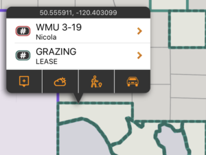
Crown Lease Land
Crown Land Lease is a type of land tenure issued under the Land Act. A Land Act Lease is issued where long term tenure is required, where substantial improvements are proposed, and/or where definite boundaries are required in order to avoid land use and property conflicts. The tenure holder is granted the exclusive use and enjoyment of the area. The tenure holder also has the right to exclude or charge the public for use of the land and/or improvements, when this is consistent with the terms of the lease. Generally speaking, permission is required for access and should be treated much the same as private land.
These boundaries are shown in teal on the map, and are built into the app as part of the subscription. They can be used even without cell coverage. Tapping on the area will give additional information about the lease type.
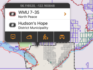
Municipalities
Municipalities have the authority to enforce shooting and hunting restrictions within their jurisdictions. By having these boundaries mapped, you can assess whether you are within the municipal boundary and subject to its bylaws.
They are shown in dark grey on the map, and are built into the app as part of the subscription. They can be used even without cell coverage. Tapping on the area will give municipality name and type.
No Hunting Areas
Some land designations forbid hunting by definition. Those area designations included in this layer are Ecological Reserves, National Parks, National Wildlife Areas and Migratory Bird Sanctuaries.This is not a complete listing of every parcel of land the dis-allows hunting, as that is an impossible task. It is merely a visualization of the defined no hunting areas as listed above. No-hunting zones described in the Hunting and Trapping Regulations, which do not have digital boundaries published by the province, are NOT included in this layer.
They are shown in black on the map, and are built into the app as part of the subscription. They can be used even without cell coverage. Tapping on the area will give the area name and designation.
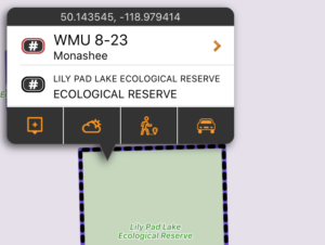
Parks and Protected areas
This layer includes the boundaries (and in some cases addition information about) Provincial Parks, Protected Areas, Recreation Areas, Conservancy Areas and Wildlife Management Areas. Specific rules for both access and hunting may exist, and are described in the Wildlife Act (hunting synopsis) or Ministry of Environment webpages. When possible, links are provided for the areas to read more.
They are shown in pale green on the map, and are built into the app as part of the subscription. They can be used even without cell coverage. Tapping on the area will give the park name and some other details.
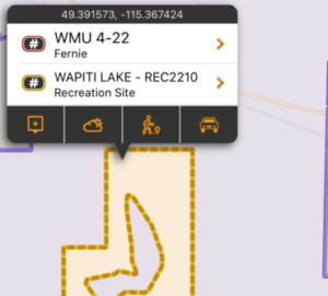
Recreation Sites and Trails
This layer includes the boundaries of Recreation Sites, Recreation Trails, and Interpretative Forests. These land types allow public access, but may have developed amenities and/or access fees for some activities. View the details of each site by tapping on them to read more details about site rules and restrictions. Internet is required to view details.
They are shown in yellow on the map, and are built into the app as part of the subscription. The boundary is visible even without cell coverage, however the details on each site requires internet access.